Hades: present-day orientation diagram
As of 2026-07-20. Reading and research orientation only. This is not a current street map, surveyed road trace, safety audit, accessibility audit, or navigation route.
Privacy: S037 is shown as a generalized literary start and not as a present-day private-residence destination.
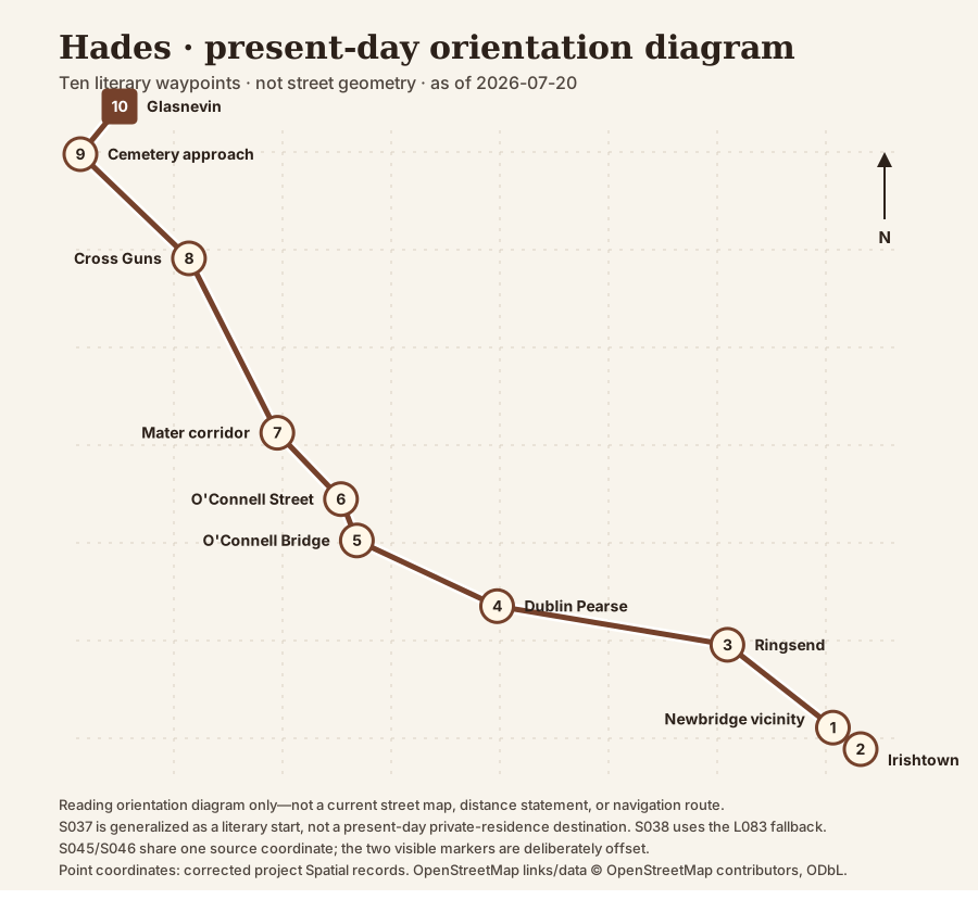
Ordered route table
| No. | Current orientation | 1904/literary orientation | Coordinate | Caution |
|---|---|---|---|---|
| 1 | Newbridge Avenue vicinity | outside fictional Dignam residence, No. 9 Newbridge Avenue | 53.336, -6.223 privacy-generalized vicinity from corrected route stop; exact property pin withheld | No. 9 is a plausible fictional address. The public current-route layer generalizes the coordinate and does not identify a present-day private house. |
| 2 | Newbridge Avenue, Tritonville Road, Irishtown Road and Dermot O'Hurley Avenue | Newbridge Avenue, Tritonville Road, Irishtown Road past Watery Lane | 53.3347, -6.2209 location-fallback; route-stop coordinate is null | Stephen is seen at a distance, not a carriage participant. |
| 3 | Ringsend Road/Pearse Street approaches and Grand Canal crossing | Ringsend Road past Wallace Bros bottleworks, Dodder bridge and Grand Canal bridge | 53.341, -6.231 route-stop | Street order is firmer than the exact minute or an individual bridge pin. |
| 4 | Pearse Street past Dublin Pearse station | Great Brunswick Street past Westland Row station, Antient Concert Rooms, St Mark's and Queen's Theatre | 53.3433347, -6.2484634 route-stop | This correction is release-layer-only pending a separately governed canonical spatial refresh. |
| 5 | D'Olier Street and O'Connell Bridge | D'Olier Street/Red Bank restaurant, Crampton memorial and O'Connell Bridge | 53.3473, -6.2591 route-stop | Boylan is seen from the moving carriage, not a funeral-party participant. |
| 6 | O'Connell Street Lower; Nelson's Pillar site now occupied by the Spire | Lower Sackville Street past O'Connell statue, Sir John Gray statue, Nelson's Pillar and west-side institutions | 53.3498, -6.2603 route-stop | Reuben J. Dodd is seen in the street and then discussed; he is not a carriage participant. |
| 7 | Parnell Square, Blessington Street, Berkeley Road and Mater Hospital | Rutland Square hill, Blessington Street and Berkeley Road past the Mater Hospital and Eccles Street | 53.3538099, -6.2651306 route-stop | Do not transfer the known demolition status of No. 7 Eccles Street to the whole multi-street corridor. |
| 8 | Phibsborough Road, Cross Guns Bridge and Prospect Road/Finglas Road approach | Dunphy's corner, Phibsborough Road, Cross Guns Bridge over the Royal Canal, then left into Finglas Road | 53.3643383, -6.2718271 route-stop | Sequence is firm; the minute remains broad. |
| 9 | Prospect Road/Glasnevin Cemetery approach | Finglas Road past Dennany's stonecutter's yard, Bengal Terrace and Prospect Cemetery railings | 53.372077, -6.2785783 route-stop | This stop shares a stored coordinate with S046; separate the markers visually without implying separate surveyed points. |
| 10 | Glasnevin Cemetery | Prospect Cemetery mortuary chapel, Dignam grave and cemetery paths including Parnell's grave | 53.372077, -6.2785783 route-stop | This stop shares a stored coordinate with S045; separate the markers visually without implying separate surveyed points. |
Ordered prose equivalent
- 1. Newbridge Avenue vicinity — Bloom joins Cunningham, Power, and Simon Dedalus in the cramped carriage behind Dignam's hearse. No. 9 is a plausible fictional address. The public current-route layer generalizes the coordinate and does not identify a present-day private house.
- 2. Newbridge Avenue, Tritonville Road, Irishtown Road and Dermot O'Hurley Avenue — Bloom points Stephen out; Simon stretches across, but the turning carriage prevents father and son from meeting. Stephen is seen at a distance, not a carriage participant.
- 3. Ringsend Road/Pearse Street approaches and Grand Canal crossing — The carriage passes the bottleworks and waterways, pausing at the Grand Canal bridge. Street order is firmer than the exact minute or an individual bridge pin.
- 4. Pearse Street past Dublin Pearse station — Travelling west, the mourners pass the station and a dense series of theatrical, religious, and commercial landmarks. This correction is release-layer-only pending a separately governed canonical spatial refresh.
- 5. D'Olier Street and O'Connell Bridge — The men salute Boylan outside the Red Bank; Bloom withdraws under their attention, and the cortege crosses the Liffey. Boylan is seen from the moving carriage, not a funeral-party participant.
- 6. O'Connell Street Lower; Nelson's Pillar site now occupied by the Spire — The cortege passes major nationalist and imperial monuments while the men tell stories of death, rescue, and debt. Reuben J. Dodd is seen in the street and then discussed; he is not a carriage participant.
- 7. Parnell Square, Blessington Street, Berkeley Road and Mater Hospital — As the men discuss suicide, Bloom passes the Mater and steals a look down Eccles Street toward home. Do not transfer the known demolition status of No. 7 Eccles Street to the whole multi-street corridor.
- 8. Phibsborough Road, Cross Guns Bridge and Prospect Road/Finglas Road approach — Cattle delay the cortege; it crosses the Royal Canal and turns toward the cemetery. Sequence is firm; the minute remains broad.
- 9. Prospect Road/Glasnevin Cemetery approach — Memorial sculpture appears commercially before the carriage stops and the men descend. This stop shares a stored coordinate with S046; separate the markers visually without implying separate surveyed points.
- 10. Glasnevin Cemetery — The service proceeds from chapel to grave; Bloom observes the burial and passes political and personal graves. This stop shares a stored coordinate with S045; separate the markers visually without implying separate surveyed points.
Research and reading orientation only. Street layouts, access, traffic, works, opening hours, and cemetery rules can change; check current official information before travel.
This project has not audited present-day step-free routes, crossings, surfaces, gradients, toilets, or transport accessibility.
Point coordinates: corrected project Spatial records. OpenStreetMap links/data © OpenStreetMap contributors, ODbL. Copyright and licence.